


Archaeology through the Keyhole
Google have the magic touch. What other company could say in their Terms and Conditions that they reserve the right not to delete your personal emails so they can build a better customer profile, and still have people queuing up for invites to the service? Like Microsoft and Yahoo! they’re collecting smaller technology companies but so far haven’t yet suffered a public-relations backlash. Blogger woes may yet trigger one, but one possible reason for their PR success is that when it comes to search they know what they’re doing. Keyhole, their most recent acquisition, is a case in point. Keyhole is a program for accessing satellite data and aerial photography. The program starts by presenting a view four thousand miles above the heart of the mainland USA. Which really is the only major quibble. The software is extremely USA-centric. For instance I now know Athens is in Georgia, Sparta in Wisconsin and Delphi in Indiana. If you are lucky the place you want to see will have satellite photography overlaid topographical data. However most of the photo data is based in the USA, European coverage is very poor. When there is the photography though it looks as though the software could be extremely useful.
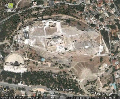
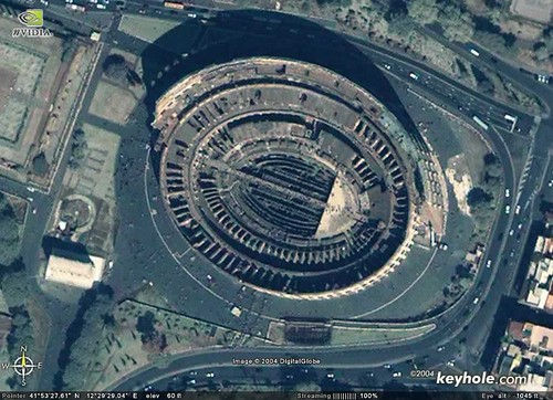
Both Athens and Rome are covered by high resolution photography, and as the images below show (click on them for a larger view), they could be used for teaching materials. It is even conceivable that primary research may be possible. In my case photos of Marsala, Palermo and Soluntum would be hugely useful. However even without this data the software might be a useful mapping tool.
As an example I’ll show a simple map of Sicily which, as ever, sits in the middle of the Mediterranean and effectively divides the western and eastern halves of the sea. I’ve overlaid icons showing the sites of Carthaginian settlement, which Thucydides said was on the side of the island closest to Africa. A simple view shows that Palermo and Soluntum are around the tip and on the shore facing away from Africa.

Along with panning across the surface of the earth, Keyhole also allows skewing of perspective. The image below is of someone a few hundred miles above central Europe looking over the Tyrrhenian sea. From this perspective it shows that the sea is an enclave connecting Sicily, the western shore of the Italian mainland and the shores of Sardinia and Corsica. From this view Thucydides makes sense.

It’s a rather simplistic example, and nothing radical to anyone looking at the Mediterranean. However, making a map to show this would be a significant undertaking. The shot below was created in a few seconds. I placed the camera over Francoforte, reduced the altitude to a few feet and the skew to horizontal. The reason I’d want to do this is to show the power that Mount Etna has in the landscape. Flipping everything back to orthogonal allowed me to use the measuring tools, which told me that Francoforte is about forty miles away from Etna. Again the presence of Etna is obvious to anyone who has visited the region, but this tool makes it easier to accurately illustrate it.
The program is a web service and costs $25 a year at the moment. For Americans interested in the modern era that’s certainly a bargain. For classicists or archaeologists the patchy coverage makes it more a useful toy than must have too. However, with Google pushing Keyhole this will hopefully change soon. If not Google, then Microsoft’s forthcoming Terraserver application will push image access forward. While email has altered what makes good scholarship, but has change the way academics work, so Keyhole and its competitors will change how we present some site data by making GIS idiot-friendly. One to watch for the future I think. —–


Comments