


My Bakken Research in 14 Mediocre Images
If you’ve been following my blog over the last couple of weeks, you’ve perhaps noticed that Kyle Cassidy has been working overtime to get us media coverage for the Bakken Goes Boom: Oil and the Changing Geographies of Western North Dakota.
His photo essay on the Bakken has appeared in Slate, Fast Co. Design, and the Daily Mail. It’s really good.
Since I just finished putting together a group of photographs and illustration with rather detailed captions, I thought I’d try my hand at a little photo essay. I’m not Kyle Cassidy, but here goes:

Figure 1: The thick line delineates the Bakken formation, and the vast majority of oil related activities take place in Mountrail, Williams, McKenzie, and Dunn counties in Western North Dakota.

Figure 2: Map showing workforce housing in the Bakken. Dots represent camps recorded in an inventory of “temporary workforce housing establishments” in the western part of North Dakota. The stars are our study sites in the region.

Figure 3: A kite photograph of a Type 1 Camp outside Tioga, ND. Note the regular arrangement of units, the elevated walkways between units, and the small common building with a flat roof in the center right of the image.

Figure 4: The alley between two rows of units in a Type 2 Camp outside of Williston, ND. The alley provides space for the electrical masts, water and sewage hookups, and for storage. It also provides access to buried pipes that sometimes require maintenance.

Figure 5: The haphazard arrangement of RVs in a Type 3 Camps near Tioga, ND. Without the constraints of electrical masts or water and sewage hook ups, in this instance, a Type 3 camp used this flexibility to create common spaces.

Figure 6: Man camps tend to cluster around the edges of existing settlements to leverage concentrations of existing infrastructure, and to avoid jurisdictional complications associated with being within city limits.
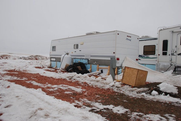
Figure 7: The use of extruded polystyrene foam around the base of an RV provides insulation. Note the use of wood braces for the foam, the insulated sewage pipe, and the wood box over the water and hookup.

Figure 8: Well-constructed wood framing to support extruded polystyrene insulation around the base of the RV. Note the panel removed for access to the underside of the RV.

Figure 9: A rather typical mudroom set atop an elevated platform with a small deck. Note the tar-paper roof, the modest efforts at decoration, and the plants set into Wal-mart pails.

Figure 10a: External platforms are among the most common architectural interventions in the Bakken. They provide a defined space elevated from mud, dirt, and snow. Note the use of a standard shipping pallet as a step.

Figure 10b: This is a common assemblage associated with the demarcated and elevated space of a platform is unsecured, and includes (a) grill (b) cooler (c) camp chairs (d) propane cylinder (e) camp table (f) shipping pallet (g) deck.

Figure 11: This is an elaborate example of demarcated property. The placement of the RV on the border of the lot forms one border for private space that is here defined by a flimsy fence, some impermanent landscaping, an elevated platform, and the personal touches including a “Brad and Brenda” sign.

Figure 12: Free weights along with elaborate grills contribute to the hyper-masculine identity present in the Bakken. Weights are often left unsecured and then abandoned when residents move on. Photo by Kyle Cassidy.

Figure 13: The two grills visible outside the mudroom of a pair of RVs in the Bakken complement a typical, if elaborate assemblage of objects associated with short-term occupation: tomato plants in planters, platforms made of shipping pallets, children’s bikes and toys, cinderblocks, and a rubber trash can.

Bonus Photo! (From Left): Richard Rothaus, Bill Caraher, and Bret Weber at the site of an abandoned man camp. Photo by Kyle Cassidy.


Comments