


Naxos

Location of Naxos.

Naxos is one of the oldest of the Greek colonies on Sicily. It sits on the north of the eastern shore of Sicily, near Mount Etna. The ancient sources agree that the city was founded at least in part, by settlers from Chalcis on Euboea but disagree on details. While Thucydides (6.3.1) states: “Of the Hellenes, the first to arrive were Chalcidians from Euboea with Thucles, their founder. They founded Naxos and built the altar to Apollo Archegetes, which now stands outside the town, and upon which the deputies for the games sacrifice before sailing from Sicily.” Ephoros of Kyme, a slightly later historian writing in the fourth century BC, (Check G.L. Barber The Historian Ephoros 1935) says that it was founded at the same time as Megara Hyblaea (FGrHist 70 F 137). Strabo (6.2.2) following Ephoros, also agrees this is one of the earliest colonies. The were founded at much the same time. The authors all agree that the inhabitants came from Chalcis, a polis in the north of the island of Euboea. The one dissenting opinon is that of Hellanicos, an author contemporaneous with Thucydides, records that it was co-founded not only by settlers from Euboea, but also from Naxos in the Cyclades (FGrH, 4 F 82).
Why the site was chosen is a difficult argument to reconstruct. Pliny the Elder (Nat. Hist. III 14) mentions it (in the form of Tauromenium, Naxos itself had been abandoned at this stage) at the city closest to Mount Etna which he notes is “wondrous for the flames which it emits by night.” It is tempting to argue that the site occupies the best beach close to the mountain and so is an easy point to aim for when navigating. This would not necessarily make it the first place to be settled, but it might make it conceptually the first place in Sicily. The archaeological evidence has been the subject of much discussion (for recent excavation see Pelagatti 1981), including a recent conference on the ties between Naxos in Sicily and Naxos in the Cyclades (Lentini 2004). So far there has been finds of geometric pottery and Euboean drinking vessels which would date from the late eighth century B.C. but while this might indicate Greek settlement it does not necessarily show the existence of a formal colony. More problematically for a colony called Naxos, there appear to be no early imports from Naxos in the Cyclades. This causes a puzzle as to how the city gained its name. Holloway (1991:49) refers to an inscription to the goddess Enyo which may shed some light on the matter. He identifies it as a goddess from Naxos in the Cyclades, which would suggest some presence of Naxians in the new city. Enyo is one of the Graiae, three women who shared but one tooth and eye between them. Enyo’s particular role was as a war goddess, her name being “horror” which would make her an eccentric choice. She is also a daughter or Phorcys, a sea god. In this role she would be a more apt deity for both Naxos in Sicily and in the Cyclades. While archaeological evidence may suggest a connection between the cities, it lacks the fine resolution required to confirm Naxos as the earliest colonised site.

Mount Etna overlooking Naxos, Mount Tauromenion in the foreground.
A more convincing explanation for the early colonisation of Naxos may be found by considering Greek navigation. Pomey notes (1996:134) that navigation in the Meidterranean during Antiquity was distinctly low-tech, being mainly a case of following the coastline with, perhaps, occasional trips across the open sea. It was the knowledge of headlands and bays that enabled sailors to navigate around the Mediterrean. This might suggest that Zancle, modern Messina, would be the first site to be colonised, being a short distance from the Italian mainland on the other side of the Straits of Messina. However, Naxos has a distinct navigational beacon which would make it an easy site to navigate to. For ships passing round Cape Spartivento, on the coast of Calabria, Mount Etna would form a prominent feature on the horizon. Sailing directly toward Etna would bring a crew ashore a couple of kilometres south of Naxos (see image below). The association of Naxos with Etna is found in Pliny the Elder’s Natural History (III.14):
“In this island [Sicily] there are five colonies and sixty-three cities or states. Leaving Pelorus and facing the Ionian Sea, we have the town of Messana, whose inhabitants are also called Mamertini and enjoy the rights of Roman citizens; the promontory of Drepanum, the colony of Tauromenium, formerly called Naxos, the river Asines, and Mount Etna, wondrous for the flames which it emits by night. Its crater is twenty stadia in circumference, and from it red-hot cinders are thrown as far as Tauromenium and Catina, the noise being heard even at Maroneum and the Gemellian Hills.”
Not even Alexandria had such a navigational aid. Malkin (2003:62) refers to the foundation of Naxos as a “Mayflower moment” meaning that the foundation of the colony opened up a new world. However he may be more accurate by noting that that history of Naxos was changed by successive generations. He notes that the altar of Apollo Archegetes would also serve as the god of disembarkation. If Etna was the target for travellers wishing to arrive at Sicily and sail along the coast then Naxos, and the altar of Apollo Archegetes would have been a symbol of foundation and beginning of all such travellers. Even if Naxos were one of a rash of colonies that spread over the east coast of Sicily at the same time, its geographical position as the first place in Sicily would have created a historical narrative that it too much have been the first site for all cities, regardless of whether or not cities rather than loosely nucleated settlements were being founded in the eighth century B.C. This would explain its position as the “first place” in Sicily.
[FLASH]http://myweb.tiscali.co.uk/provenancedesign/navigation.swf?aid=939057, 500, 407[/FLASH]
The city appears to have grown rapidly, covering an area of around 100 hecatres within a century of settlement (Janelli and Longo 2004:15). Settlement seems to have expanded along a planned city grid orientated north-south (n degrees from north get data from Lentini). Some of the buildings in this early phase are, predictably, somewhat simpler than the later grand temples of the classical period. In a couple of cases ritual buildings have been identified by the presence of shrines (get data on E and F). However, two early temples are known to date from the Archaic period.

Wall of Temple B. Wall of Temple A of to the left of picture.
The sanctuary of Aphrodite is located in the south-west of the archaic city. It dates from the latter half of the seventh century BC and appear host a variety of sacred edifices. The altars are numerous. There are also two remains of temples, one built over the other, indicating rebuild of a temple to one deity (see image above), presumably Aphrodite. The walls of the temples are well enough preserved to enable measurement of an orientation. The walls of Temple B are the most prominent, being broad. Orientations were measured along two axes. Temple A is has been obliterated in places, but nonetheless a wall survived with enough length to justify measuring an orientation. However no altitudes were recorded for either temple. This was due to the lush vegetation present which prevented a view of the horizon. As with other urban sites, there remains the question as to whether the houses of the city were perceived as obscuring or creating the local horizon.
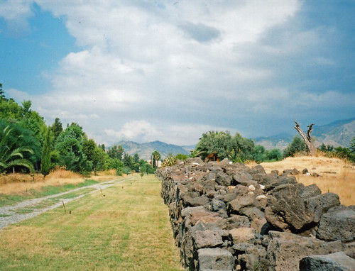
City Wall at Naxos.
The sanctuary was surrounded by boundary which adjoins the strongly fortified city wall. This is thought to be of later date, around the end of the sixth century, though it doubtless respected the temenos, the religious boundary, of the site at the time. This provided further details to be measured to allow for orientations to be measured and checked against an archaeological plan of the site.
There is another sacred area is found outside of the city. The size has been used to argue that this was the site dedicated to Apollo Archegetes. The area appears to have been used from the seventh century until the Hellenistic period. In addition there are further small temples in the east of the city, but so far no attribution can be made.
The city underwent a radical redesign in the fifth century, following the conquest of the site by Hieron of Syracuse in 476BC. The city was re-laid and resettled, probably by Doric mercenaries. The new orientation of the city grid was rotated at forty-five degrees to the archaic grid and seems to indicated an effective re-colonisation of the site. The new grid is very much an expression of the Hippodameon ideal, with wide streets (plateia) crossed orthogonally by narrower routes (stenopos) creating regular blocks of four houses. This later grid would appear to be economically motivated, being aligned with respect to the local coast. The logical nature of the latter grid would therefore raise the question as to why the earlier grid was not also similarly aligned.
Temple A, the earliest temple to Aphrodite is aligned 41º from north. This is declination +29º. Not only is this too far to face sunrise, it also misses the most northerly rising of the moon. While there is vegetation obscuring the horizon (see above), it is unlikely that it could be low enough to allow it to face moonrise. It is, just, aligned on the zodiacal constellation Gemini, and every other constellation at +29º. It is hard to argue this is significant. The Greek calendar is primarily lunar (Hannah 2005, Pritchett ). While, following Hesiod, it has been argued there is a stellar component in calibrating the Greek calendar (Salt and Boutsikas 2005), there are no plausible stellar alignments claim for Greek temples.
Temple B, the rebuilt temple, faces further south. Along the long side azimuths of 61º and 62º were measured. This indicates it was facing the sky towards a declination of +21.5º, which would be the direction of sunrise in the first week of June, or the last third of July.

Wall of Temple A at Naxos.
In light of this it would be tempting to argue that Temple A was an attempt at a solsticial alignment that was incorrectly built. The sun rising would move to the south of the sunrise point, rather than the north. A build aligned on sunrise would therefore be expected to be south of the correct point, and certainly not ten degrees to the north. An alternative explanation would be that the temple was aligned away from sunset. This has been suggested by Erin Nell for some Greek temples (get SEAC ref). The higher horizon to the west would cause the sun to set earlier than for a flat horizoned site. This would mean a temple laid out by the shadow of a gnomon at sunset would face further north than would be expected. The horizon would have to be high, but the horizon to the west is Mount Etna. This also matches the alignment of the street grid, but given the grid is of later date this is unlikely to have affected the temple alignment.
Tempietto C – still lacking data – azimuths measured facing north and west were 23º and 294º respectively. Given the entrance was at the east, this yields an azimuth of 113º or 114º. This faces a declination of -19º. This is the direction of sunrise on the first of February, or the twenty-second of November, plus or minus a couple of days.
Additional results. The Plateia are aligned to 61º (declination +22º dates as for the temple B), the Stenopos to 151º (too far south to be solar aligned). Usually it could be argued that the street grid defines the orientation of temples, as the block define the gaps temples must fit into. As this is the relaid street grid, this came after temple B. It is possible that the Temple of Aphrodite was used as a reference for the new grid.

Altar at Naxos.
An altar was measured in the sanctuary. The azimuths measured were 75º and 169º. No altitudes could be measured due to the presence of nearby buildings, though this raises the question of whether buildings of similar height obscured the horizon in ancient times, and so whether or not a strong, or indeed any, astronomical alignment was sought. If the horizon were flat then the altar would have faced a declination of +11.5º, facing sunrise at the end of April or at the very start of September, but it is hard to argue this is significant without further data.
Pliny the Elder, Natural History. ed. John Bostock, M.D., F.R.S., H.T. Riley, Esq., B.A. « http://www.perseus.tufts.edu/cgi-bin/ptext?lookup=Plin.+Nat.+3.14 »
Strabo, Geography. ed. H.C. Hamilton, Esq., W. Falconer, M.A. « http://www.perseus.tufts.edu/cgi-bin/ptext?lookup=Strab.+6.2.2 »
Thucydides, History of the Peleponnesian War « http://www.perseus.tufts.edu/cgi-bin/ptext?lookup=Thuc.+6.3.1 »
Holloway, R.R. 1991. The Archaeology of Ancient Sicily. Routledge.
Lentini, M.C. 1991. Naxos La Prima I Greci in Occidente. Archeologia Viva 17. 1-17? (on order).
Lentini, M.C. 2004. Le due città di Naxos : Atti del Seminario di Studi Giardini Naxos 29-31 Ottobre 2000. Giardini Naxos : Comune di Giardini Naxos.
Malkin, I. 2003. Networks and the Emergence of Greek Identity. Mediterranean Historical Review 18 (2). 56-74.
Pelagatti, P. 1981. Bilancio degli Scavi di Naxos per l’VIII e il VII sec a.C. Annuario della Scuola Archeologica di Atene n.s. 43, 291-311.
Pomey, P. 1996. Navigation and Ships in the Age of Greek Colonisation. The Western Greeks: Classical Civilization in the Western Mediterranean. ed. G.P. Caratelli. 133-40. —–


Comments